Forecast Update 05/01/26: Cool Pattern Takes Hold - Frost Looms, Wet Weather Persists
- Geddy Davis
- May 1
- 3 min read

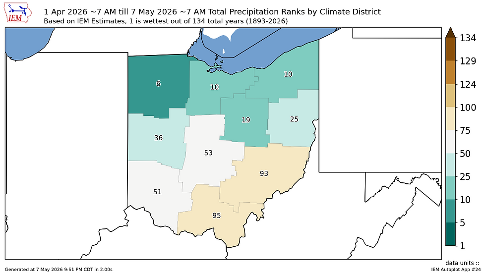
Throughout the week, the story has been the buildup to a much cooler-than-normal temperature pattern being ushered in by a change in the jet stream. Now as we prepare to close the period, we are about to experience the first of multiple shots of late season cold. While this pattern will put a hold on the active severe weather pattern both Ohio and the greater Midwest have been experiencing, chances for rain and isolated storms will not halt completely as multiple disturbances drop out of the northwest as a part of this larger low-pressure pattern. These will help keep spotty chances of rain in the forecast as well as reinforce cooler-than-normal air across Ohio for at least the next 10 days.

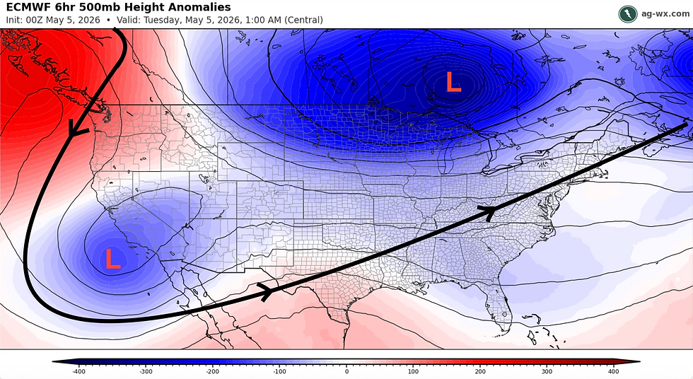
A look at the upper atmosphere to begin the day shows the first "shortwave" trough associated with the larger low-pressure pattern parked over Hudson Bay, Canada has arrived in the Midwest. As a result, dreary conditions are draped over much of the state. Rain showers are in progress over much of Northern and Western Ohio, with overcast conditions throughout the rest of the region. This activity will persist through the late morning before winds shift around out of the northwest by afternoon, heralding the arrival of the main "cold-for-May" airmass. High temperatures in the 50s will be prevalent despite clearing skies by later in the day.

The big story as emphasized over the last few days will be low temperatures tonight and Saturday night. Lows in the 30-35°F range will be prevalent with potential for frost/freeze conditions especially in rural or low-lying areas. Frost Advisories and Freeze Watches have been posted in many Western Ohio counties where the highest chance of frost/freeze conditions exists tonight. An even more widespread frost risk exists Saturday night with clear skies and calm winds encouraging frost development. The highest risk again existing in Western Ohio but fair chances across most of the rest of the state, including within warmer urban areas. This will be enough to zap any outdoor plants that are not cold hardy, so cover up those sensitive sprouts and move those pots inside!


NWS low temperature forecast + anomaly for the Great Lakes for Saturday morning (top) and Sunday morning (bottom). Courtesy: ag-wx.com
Aside from the pressing frost risk, weather over the weekend will be un-impactful. Partly to mostly cloudy skies on Saturday will give way to mostly clear skies on Sunday. Highs on Saturday will linger in the low 50s before warming into the low to mid 60s on Sunday, beginning a gradual warming trend as cool air blast #1 moves out of the region and southerly winds advect more seasonal air back to the state heading into the new week. Highs into the 70s will return for most by Monday and Tuesday. Chances for rain will also return beginning Sunday night and Monday, as the first of several disturbances moves in from the northwest and meets just enough moisture return from the south to create some light but meaningful precipitation chances, especially for those in Southern Ohio looking to hold off nagging dry soil conditions.
A more substantive storm system looks to take shape Tuesday and Wednesday next week, bringing an increased probability of some thunderstorms and heavier precipitation. We will start off next week's postings by addressing this potential. Have a great weekend!
GRD