Mid-Week Forecast 05/06/25: Wave After Wave
- Geddy Davis
- May 6
- 4 min read

On a typical schedule, this blog will post longer forecasts on Monday, Wednesday, and Friday with shorter forecast "updates" and other content on Tuesday and Thursday. That cadence has been a little out of whack due to just starting out, getting into a routine, and tinkering with a couple other methods of content delivery. However, now that a little bit of a rhythm has been established, we're going to take a crack at a longer post. The run-of-show for these longer posts will go something like this:
Review of forecast-to-date (aka: what has happened since the last "big" forecast post)
Forecast adjustments (has anything changed in the forecast for the remainder of the period)
Long-term look (can we start to forecast what might go on next week?)
These will be good days (start of week, middle of week, and leading into the weekend) to take stock of these points while also keeping the discussion digestible. We'll see how it rolls going forward, maybe the day-to-day updates will be the most efficient, who knows! So, with that bit of housekeeping out of the way, let's get into it.
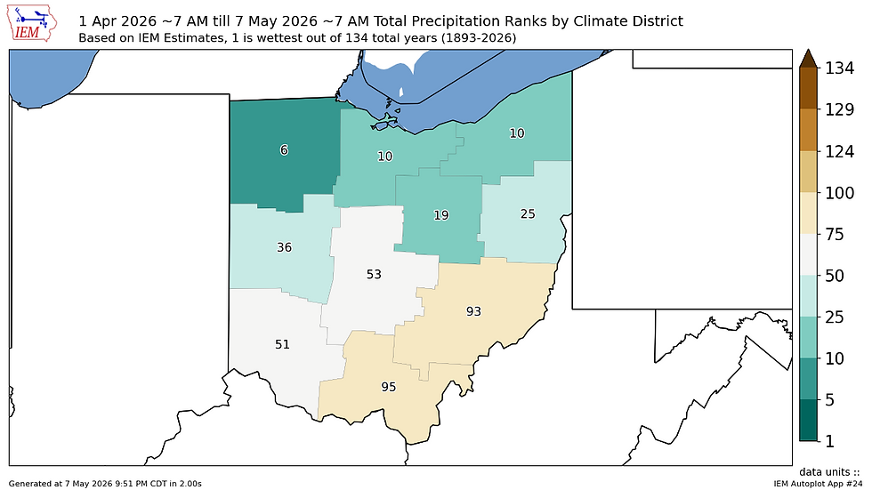
Despite a complicated evolution with two interacting weather systems to start the week, the progression of Monday and Tuesday played out pretty much as anticipated. Monday brought a mild start to the week with pleasant albeit windy weather, and only late Monday night/early Tuesday morning did the first signs of unsettled weather move in with some light showers in Western Ohio left over from decaying Illinois and Indiana thunderstorms. This transitioned into more consistent, widespread rainfall starting late Tuesday morning in Northwest and Northern Ohio before overspreading Central and Southern parts of the state by Tuesday evening. Timing of this overspread was a little bit later than anticipated owing to a smaller initial surge of moisture than forecast. By evening however, most areas of the state were sufficiently saturated. The cold front was also more progressive than forecast. Much of the state is already behind the front as of this morning with temperatures down in 40°F range as of 8am. Rainfall totals are generally on pace with the 0.50-1.50" forecast especially across the middle third of Ohio.


The day today will start out as dreary, damp, and cool once again as the cold front continues to work its way out of the state. Some lingering drizzle or rain showers will remain in parts of Central, Southern, and Eastern Ohio, while Northern and Western Ohio begin to dry out as early, with dry conditions gradually spreading across the rest of the state by late afternoon. Some areas may even see some sun depending on the pace of clearing. From here, we will resume our chilly nights and cool days, with highs today through Thursday only reaching the upper 50s/low 60s for most and low temperatures generally in the upper 30s/low 40s. There does appear to be a slight chance of some patchy frost in rural areas tonight and Thursday night, though any development will likely be in very localized areas where lows may dip below 36°F. No large-scale advisories are in effect, but with the persistence of this cool pattern, it is best to hedge on the side of caution especially with any cold sensitive plants.
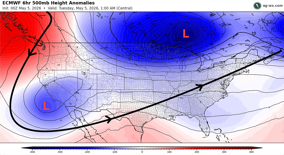
The tail end of the week into the weekend looks like more of the same conditions, as this persistent Hudson Bay low pressure trough continues to be the dominant driver of our weather to start the month. Smaller atmospheric disturbances, or "shortwaves", will rotate counterclockwise around the trough and into the Great Lakes and reinforce our cool, wet pattern through the weekend and into next week. This national view of the jet stream at 500mb helps to illustrate this, with at least two "ripples" in the flow moving through Ohio: one Friday-Saturday, and the other Sunday-Monday.

Each one of these waves will bring a chance for more rainfall as well as continued below-average temperatures. The first example of this will be on Friday, where highs in the mid-upper 50s look to persist for much of the state before the first shortwave arrives and brings chances for light rain to close the night. However, with these disturbances being weaker and more compact compared to the system moving out of the region at present, the impacts will be quick and there will even be chances to warm up our high temperatures slightly in between waves over the weekend thanks to a quick reversal back to southwesterly winds, which will push potential high temperatures into the 70s over the course of Saturday and Sunday. This will be short-lived however, as the second shortwave brings more chances for showers, and a more well-defined cold front which will drop temperatures down into the low 60s once again by early next week. This back-and-forth with primarily cooler, wetter conditions is signaled to be persistent beyond the weekend into the next week and a half as indicated by several ensemble model runs and backed the Climate Prediction Center's recent 6-10 day outlook.

For now though, clearing skies and cool but pleasant weather is anticipated to round out the week for much of us as this slow-moving system clears the region. Chilly overnight lows will be present but should stay warm enough to avoid widespread frost potential outside of a few localized areas. From Friday onward, chances of showers look to sandwich a brief warming trend over the weekend.
GRD