Weekend and Beyond 05/08/25: Cool and Wet Continuation, Hope for a Warmup?
- Geddy Davis
- May 8
- 4 min read

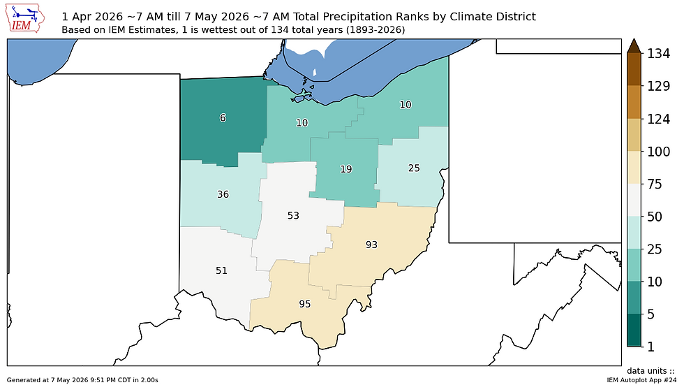
Took another raincheck with posting yesterday, as I had the opportunity to attend the Ohio Stormwater Conference up in Sandusky, OH where several different stormwater utility providers, design firms, engineers, and support personnel met. A few times throughout the event, individual conversations drifted to how Ohio's spring has really gone over to particularly wet in the last 30-40 days, especially in Northern Ohio where the event was being held. This got me thinking where this stretch fell in the state's climate division record. Sure enough, a quick map generation quantified what many suspected: if you were to compare the April 1st-May 7th timeframe across Ohio's climate record, this year's stretch is up there with some of the wettest recorded in Northern Ohio, with all three zones scoring in the top 10 of the record. Its likely these ranks would be higher still if the measurement convention started at midnight April 1st instead of 7am, as a heavy rainfall event was ongoing that night. In addition, persistent wetness continued to be observed across the middle third of the state in this plot as well, with only southern and eastern divisions on the "dry" side of the record. However, any low-grade drought impacts in SE Ohio have been kept at bay by timely rainfalls.
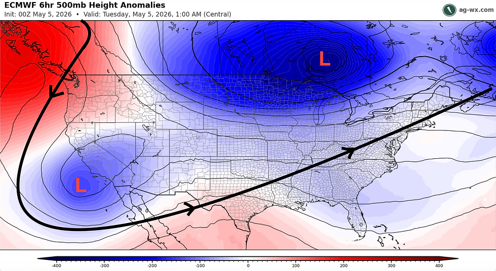
So, when can we see a break from this wet stretch? Unfortunately, not anytime in the short-term. Continued disturbances associated with our persistent Hudson Bay trough pattern remain in the outlook, the first of which arrives today. Increasing clouds, strengthening southwest winds, and a few scattered showers are expected throughout the region to start the day. More persistent rainfall is expected to begin in the evening hours, starting in western Ohio and progressing eastward overnight. The heaviest precipitation potential exists in portions of Southwest Ohio, where another 0.50-1.00" of rain is possible with lesser totals surrounding this corridor.

Areas in Eastern Ohio may see rain linger into Saturday morning. However, once this wave exits the state, a generally pleasant Saturday is expected, with skies clearing from west to east and temperatures in the 70°F range for the first time in a few days. A few scattered showers or storms are possible as the afternoon and evening goes on thanks to the emergence of yet another subtle disturbance in recent forecast trends.
Yet another disturbance arrives Sunday morning, with widespread cloudy skies and more chances for showers especially in the northern half of the state. This disturbance will bring a stronger cold front compared to the Friday system, which will drop temperatures below average once again. Some highs in northern Ohio may not make it above 60°F, while areas south of the front in southern Ohio may reach 70°F before the front goes by. Regardless, all areas can expect another chilly night Sunday night, with lows ranging from the upper 30s in the north to mid 40s in the south. Another isolated frost chance may exist in Northern Ohio should temperatures get below 36°F, but if this occurs it will be highly localized.
A look at the extended outlook features more of the same headed into next week: average to below average temperatures and yet another wave of rainfall arriving Tuesday and Wednesday. However, there are hints that a break from this pattern may finally be emerging, with potential to see noticeable changes as early as Thursday-Saturday next week (May 14-16). This change may feature our nagging Hudson Bay trough finally getting dislodged from its position, and replaced by more consistent zonal (aka: flat) jet stream flow or even an area of high pressure that may build into parts of the Midwest. Either outcome would bring more seasonal temperatures and a break from the every-other-day rainfall the state has been experiencing.

In summary: cooler and wetter weather continues today and tonight, with the heaviest rain potential this evening in parts of the south and west. The state will get a warm weather break for most of the day on Saturday, though scattered shower and storm chances will still be present, especially into the morning Sunday as yet another cold front sweeps through and drops temperatures. Relief from this pattern may be in sight, but not until late next week.
GRD